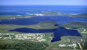
What makes this southwestern corner of Australia such a magical place? We endeavour to find out in the series of articles that follows this brief explanation of what defines Walpole & Districts.
Where and what is Walpole & Districts?
Walpole township lies within the boundaries of the Shire of Manjimup, which is centred around Manjimup town 120 km to the northwest of Walpole.
Walpole’s sister settlement Nornalup lies within the boundaries of the Shire of Denmark, which is centred around Denmark town 66 km to the east of Walpole.
Thus the Community Opportunity Workshop that took place in 2000 defined “Walpole & Districts” as being the Nornalup/Kent Ward of the Shire of Denmark and the Walpole Ward of the Shire of Manjimup.
In terms of regional Western Australia, Walpole & Districts encompasses southern parts of the “South West” and western parts of the “Great Southern”, from the Shannon River to Kent River.
Walpole & Districts’ relative isolation has fostered a spirit of self-reliance and self-determination among the residents of the area.
Consider these facts (and claims):
- The population of Walpole & Districts is less than 500 residents, yet more than 250,000 tourists visit the area each year;
- The wettest and greenest town in Western Australia, Walpole enjoys a mild climate with average minimum-maximum temperatures of 5°-15° Celsius in winter and 10°-25° Celsius in summer;
- Walpole & Districts is said to have the cleanest air in the world;
- The Deep River is said to be the most pristine river in Australia;
- Walpole & Districts is home or adjacent to some 10 national parks, including the rich Walpole-Nornalup Inlets Marine Park, the legendary Valley of the Giants and the iconic Tree Top Walk.
No wonder then that the WA State Government (with broad local support) is considering nominating the “Walpole Wilderness” for listing on the National and World Heritage registers.
What is the Walpole Wilderness?
Established in 2004, the Walpole Wilderness area is an international biodiversity hotspot, protecting the threatened habitats of endemic flora and fauna. The ancient area is also recognised for it’s rich Aboriginal heritage.
Walpole Wilderness incorporates Walpole-Nornalup, Mount Frankland, Shannon, Mount Frankland (South and North), Mount Roe, and Mount Lindesay national parks, the Walpole and Nornalup Inlets Marine Park, as well as a range of conservation areas and nature reserves. Nearby are the William Bay and D’ Entrecasteaux national parks.
The Wilderness features a vast, natural landscape incorporating the very essence of Western Australia’s southern forests and coastline: majestic jarrah, tingle and karri forests; imposing granite peaks; tranquil rivers, wetlands and inlets; sheer coastal cliffs; picturesque beaches; and the rich Southern Ocean.
The Department of Parks and Wildlife (DPAW), the Walpole, Nornalup & Districts Community Development Group (CDG), the Walpole CRC and the wider Walpole & Districts community are broadly in support of National and World Heritage listing and are conscientiously laying the foundations for this process to advance.
Find out what makes Walpole & Districts such a magical place in this series of articles:

